


A historic El Niño is building
A very strong El Niño is taking shape in the tropical Pacific. In its October 8 update, NOAA’s Climate Prediction Center gave an 83% chance that October–December 2026 will reach a strength exceeding every El Niño on record since 1950, and a greater than 90% chance of a very strong event through the Northern Hemisphere fall and winter.
Most of the conversation so far has focused on winter storms, rain, and snowpack, but the El Niño–Southern Oscillation (ENSO) also reshapes where wildfire losses are most likely to occur across the U.S. To see how much, we compared wildfire average annual loss (AAL) from our stochastic wildfire model under El Niño and La Niña conditions.
ENSO in 30 seconds
ENSO is a recurring swing in sea surface temperatures and atmospheric circulation patterns across the tropical Pacific. Its warm phase, El Niño, and its cool phase, La Niña, shift the jet stream and storm tracks over North America, changing temperature and precipitation patterns for months at a time. Those changes affect fuel moisture, the number of critical fire weather days, and ultimately how much property is exposed to damaging fire.
Leveraging KatRisk’s model to study ENSO
All of KatRisk’s models are linked to the same stochastic sea surface temperature catalog. This shared catalog allows us to examine the impact of ENSO on wildfire losses directly. We split our stochastic wildfire catalog into two groups based on the ENSO index in each simulated year: years with a positive index (the warm, El Niño-leaning phase) and years with a negative index (the cool, La Niña-leaning phase). Every simulated year falls into one group or the other; there is no separate “neutral” category, so our results reflect the typical tilt of each phase rather than only full-strength El Niño or La Niña events. We then compared average annual loss (AAL) for each group against the full catalog as a baseline and calculated the percent change for each state and county.
Losses during El Niño and
La Niña
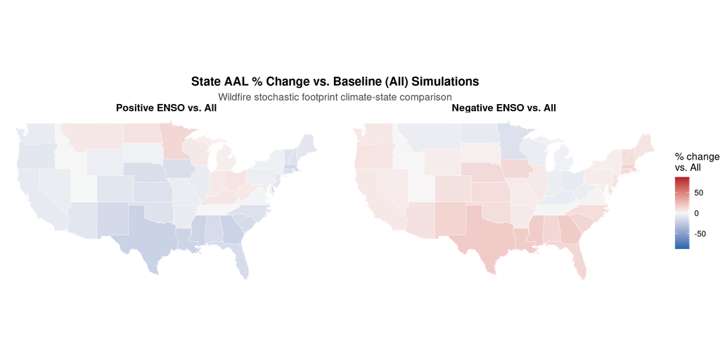
- The southern U.S. is a near mirror image. Under El Niño, wildfire AAL drops across almost the entire southern tier, from California and the Desert Southwest through Texas, the Gulf Coast, Georgia, and Florida. Texas and Georgia see the largest decreases, at about 21% and 20%, with Florida down about 15%. Under La Niña, the pattern flips: AAL rises about 19% in Texas, 18% in Georgia, and 14% in Florida.
- The midwestern states move the other way. El Niño raises AAL in parts of the northern U.S., including Montana, North Dakota, Minnesota, Wisconsin, Michigan, and the Ohio Valley (Indiana, Ohio, Kentucky, West Virginia). La Niña lowers AAL in several of those same states, especially Minnesota.
- The West and Plains are similar to the south. Washington, Oregon, California, Nevada, and Arizona see modest decreases under El Niño and modest increases under La Niña. In California, the swing is relatively small in our results, about 7% lower under El Niño and 6% higher under La Niña. Because our analysis includes weak ENSO years alongside strong ones, these numbers likely understate the effect of a full-strength event. The central Plains follow the same La Niña-up, El Niño-down pattern, with Colorado about 10% lower under El Niño and 9% higher under La Niña. Even so, ENSO’s influence in these regions is more muted than in the South, so other factors, like Santa Ana and Diablo wind events, play a bigger role in shaping the wildfire season.

- Counties show the same story, with more texture. At the county level, the broad north-south split holds, and the La Niña signal across the Southeast and southern Plains is especially consistent. We masked 473 of 3,098 counties with baseline AAL under $10,000, since small dollar changes in very low-risk areas can look dramatic in percentage terms. A few Midwest counties still show sharp swings in both directions; those are best read as noise rather than a meaningful ENSO signal.
ENSO’s impact on the weather
During El Niño, the subtropical jet stream typically strengthens, bringing a cooler, wetter winter and spring to the southern U.S. That keeps fuels moist through the late winter and spring fire season and reduces fire risk in Texas, the southern Plains, and the Southeast. Meanwhile, a persistent ridge forms over the Upper Midwest, causing warm, dry conditions that lead to increased wildfire risk.
La Niña does the opposite, typically leaving the southern U.S. warmer and drier. Several high-impact fire events have occurred during La Niña conditions, including the record 2011 Texas wildfire season and the January 2025 Los Angeles fires.
Our results line up well with a recent NOAA-led study of U.S. wildfire area burned from 1984 to 2022 (Hoell et al., 2026). It found that an autumn La Niña more than doubles the chance of extensive area burned in the Southern region the following winter and spring, while an autumn El Niño reduces those chances across the Southern, Southwest, and Rocky Mountain regions and raises them in the Northern Rockies and Eastern regions. Southern California showed one of the most consistent signals of all: a year-round decrease in extensive area burned during El Niño.
NOAA’s U.S. Winter Outlook for December 2026 through February 2027 points the same way. It favors wetter-than-average conditions across the southern tier, from the Southwest to the Southeast, and expects drought to improve or end across the Southwest, Southern Great Plains, and Southeast. These are the same regions where our model shows wildfire losses dropping under El Niño. Meanwhile, NOAA favors warmer-than-average temperatures across much of the northern U.S. and expects drought to develop or worsen in parts of the northern Rockies, eastern Washington, and northeastern Oregon. That fits the higher El Niño losses we see in parts of the northern tier.
Wet now, fuel later
There is a catch to a wet El Niño winter. The same rain that suppresses fire in the near term also creates more grasses and other fine fuels. When that vegetation cures and dries out, it can carry fire quickly across the landscape, sometimes a season or more later.
Research backs this up. In California, ENSO events over several years can lead to vegetation buildup that increases the fuel available to later wildfires, and in the Pacific Northwest, wetter conditions after La Niña appear to boost fine-fuel growth ahead of the following summer’s fire season (Hoell et al., 2026). A global analysis co-authored by Technosylva researchers found that climate patterns often affect burned area 6 to 9 months later, through biomass accumulation, not only in the season they occur (Cardil et al., 2023).
This delayed fuel effect matters this year in particular. If a very strong El Niño grows a large fuel crop across the Southwest and southern Plains and a drier La Niña follows, wildfire losses could swing from below average to well above average within about a year.
A quieter average is not a quiet season
Everything above describes average annual loss. A lower average does not mean a season without major fires. Even in a below-average year, one wind-driven fire in the wrong place can drive large losses.
Our stochastic catalog shows exactly that. Under El Niño-leaning conditions, the odds of a damaging wildfire year go down, but not by much. About 17% of El Niño-leaning years still produce U.S. wildfire losses above the 5-year return period level, compared with 20% across all years. Roughly 1 in 12 (8.6%) still exceed the 10-year level, compared with 1 in 10 overall. La Niña-leaning years push those odds up, to 22% and 11%. The takeaway for insurers and risk managers: El Niño tilts the odds, but a costly wildfire year is still very much on the table.
ENSO is not the only teleconnection that matters
ENSO gets the headlines, but it is one of several large-scale climate patterns that influence wildfire. In a global analysis by Cardil et al. (2023), the Tropical North Atlantic (TNA) sea surface temperature pattern was linked to more of the world’s burned area (about 26%) than ENSO (about 8%), and the U.S. relationships were more complex than a simple north-south split; links in the western U.S. were generally weak. The relative importance of ENSO versus the Atlantic is still debated, but it is a good reminder that this year’s outlook depends on more than the Pacific.
What this could mean for 2026–27
- Lower expected wildfire loss across the southern U.S. if this El Niño delivers its typical wet winter and spring, especially in Texas, the Gulf Coast, and the Southeast.
- Elevated loss potential in parts of the northern states, including the Upper Midwest and Ohio Valley.
- No room for complacency. Large loss events remain possible even in a below-average year.
- A watch item for 2027–28. Very strong El Niño events are often followed by La Niña, which in our results is the higher-loss state for much of the southern and western U.S. Combined with a wet-winter fuel crop, that transition deserves close attention.
ENSO shifts the odds; it does not set the outcome. NOAA itself notes that a stronger El Niño does not guarantee larger impacts, and wildfire losses still depend on wind events, ignitions, and where fires happen to start relative to people and property. For anyone managing a wildfire portfolio, knowing which way ENSO tilts the risk, region by region, is a useful starting point for the year ahead.
Want to see how ENSO affects your portfolio?
Book a demo to learn more about KatRisk’s Wildfire model.
Sources:
- NOAA Climate Prediction Center, ENSO Diagnostic Discussion, October 8, 2026: https://www.cpc.ncep.noaa.gov/products/analysis_monitoring/enso_advisory/ensodisc.pdf
- Hoell, A., et al. (2026). The relationship between the El Niño-Southern Oscillation and extensive wildfire area burned in contiguous United States Geographic Area Coordination Centers. Journal of Geophysical Research: Atmospheres, 131, e2025JD045436. https://doi.org/10.1029/2025JD045436
- Cardil, A., et al. (2023). Climate teleconnections modulate global burned area. Nature Communications, 14, 427. https://doi.org/10.1038/s41467-023-36052-8
- NOAA, “El Niño looms large over U.S. Winter Outlook,” October 15, 2026: https://www.noaa.gov/news-release/el-nino-looms-large-over-us-winter-outlook


